


The study found that Sussex County’s privately owned property is the most suitable for marsh migration.
As sea level rise along Delaware’s coast, the state is preparing for the natural shift of its tidal wetlands.
A new mapping study released by the Department of Natural Resources and Environmental Control (DNREC) outlines where these critical ecosystems are most likely—and most able—to move in the coming decades.
The study, led by DNREC’s Wetland Monitoring and Assessment Program and Coastal Programs, identifies and scores areas across the state based on their “suitability” for future marsh migration.
This process, also known as wetland migration, involves tidal marshes shifting inland to escape inundation as sea levels rise.
Using geographic information system (GIS) data, the study evaluated land across Delaware under three sea level rise (SLR) scenarios—2 feet, 4 feet, and 7 feet. Under the mid-range 4-foot SLR scenario, the model found 21,449 acres statewide were highly suitable for marsh migration.

Sussex County tops the list
Sussex County was identified as having the most potential, with 9,418 acres rated as highly suitable.
Kent County followed with 8,482 acres, and New Castle County had 3,549 acres.
The suitability scores—ranging from 0 (unsuitable) to 12 (highly suitable)—were based on factors such as elevation, land use, and proximity to current tidal wetlands.
The findings help pinpoint not just where wetlands are likely to go, but also where efforts to support that movement should be focused.
Most suitable land is privately owned
The study found that roughly 70% of the most suitable areas are currently made up of non-tidal wetlands and agricultural land—and most of that land is privately owned.
DNREC officials say this underscores the importance of working with landowners to ensure that these ecological shifts can occur naturally and successfully.
Lower-scoring areas may still support wetland migration under certain conditions, according to the study, but may face barriers like disconnected waterways or urban development.
Planning tool for conservation and climate resilience
Beyond identifying land, the mapping effort is also intended to serve as a tool for planners, conservationists, and property owners to better manage land use and strengthen Delaware’s climate resilience.
The state has produced both a technical report and a simplified outreach flyer to help different audiences understand and apply the results.
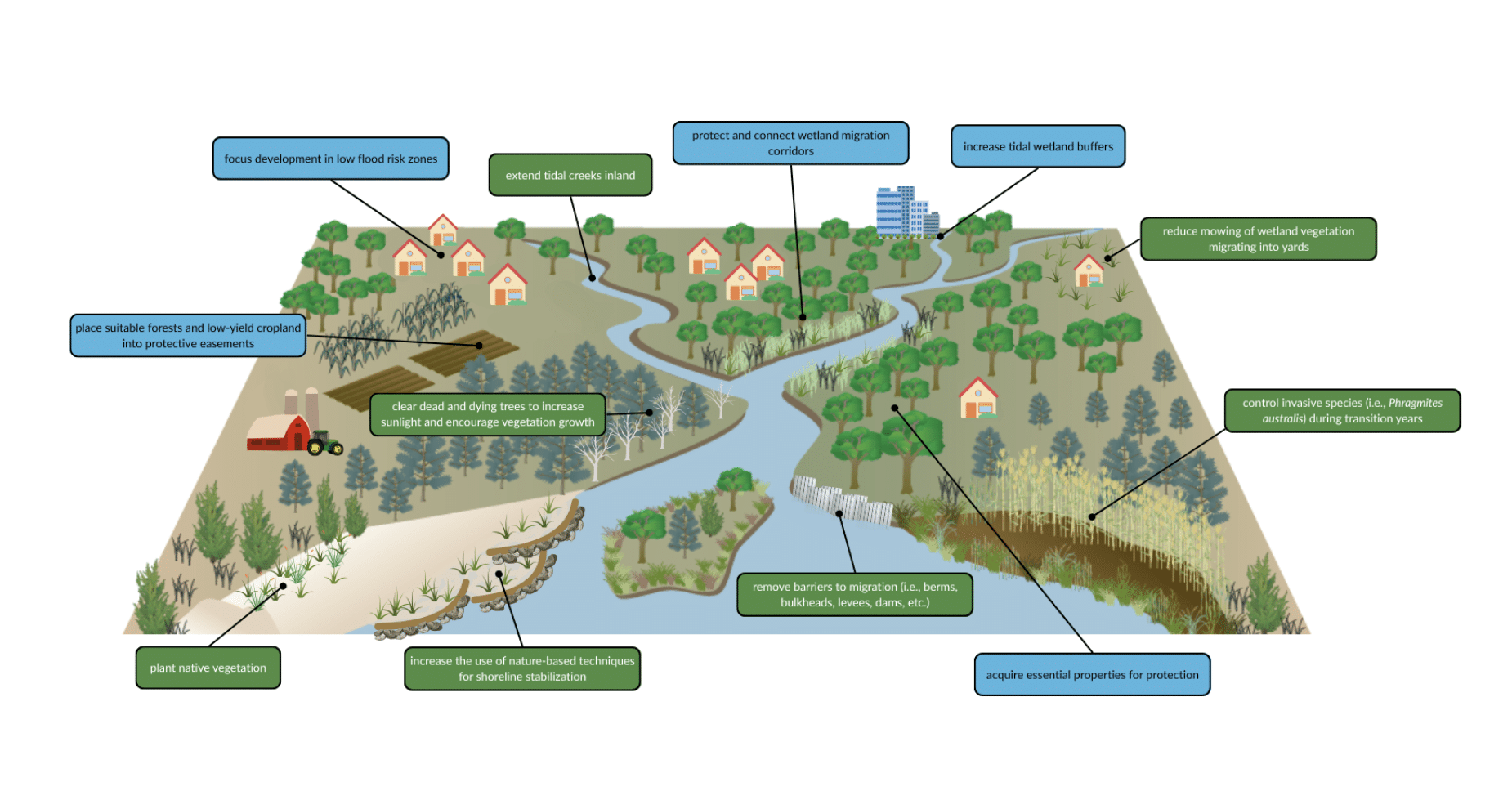
Among the study’s recommended uses:
- Prioritizing conservation of highly suitable land
- Identifying barriers to wetland movement
- Integrating migration paths into public land management plans
- Encouraging collaborative planning with stakeholders
The updated study builds on DNREC’s original 2017 marsh migration model, reflecting new data and evolving climate projections.
An interactive version of the 4-foot sea level rise scenario has been made available via FirstMap Delaware, the state’s public geospatial data platform.
DNREC hopes the findings will guide local governments, landowners, and conservation groups in making informed decisions that support both ecological and community resilience.
RELATED STORIES:
![Milford Awarded T-Mobile Hometown Grant to Build New Downtown Public Restrooms]()
Milford Awarded T-Mobile Hometown Grant to Build New Downtown Public Restrooms
12/12/2025![The Balancing Act: How Milford Caregivers Juggle Work, Family, and Caring for a Loved One]()
The Balancing Act: How Milford Caregivers Juggle Work, Family, and Caring for a Loved One
12/12/2025![Bayhealth is bringing Intuitive’s TOME Truck to the Blue Hen Corporate Center in Dover. (Photo courtesy of Bayhealth.)]()
Bayhealth Opens First Dedicated Heart Failure Clinic in Kent and Sussex Counties
12/12/2025![DRBA Police Added to Lewes–Rehoboth Police Accountability Committee]()
DRBA Police Added to Lewes–Rehoboth Police Accountability Committee
12/12/2025![Delaware Lottery Joins Global Campaign Aimed at Preventing Youth Gambling]()
Delaware Lottery Joins Global Campaign Aimed at Preventing Youth Gambling
12/11/2025![Community remembers ‘Brent’ Herd on Saturday in Milford @1:00.]()
Community remembers ‘Brent’ Herd on Saturday in Milford @1:00.
12/10/2025![Bayhealth is bringing Intuitive’s TOME Truck to the Blue Hen Corporate Center in Dover. (Photo courtesy of Bayhealth.)]()
Bayhealth Identifies Top Health Priorities in Latest Community Assessment
12/10/2025![Delaware Lottery Winner Claims $10,000 Prize]()
Delaware Lottery Winner Claims $10,000 Prize
12/10/2025


Raised in Doylestown, Pennsylvania, Jarek earned a B.A. in journalism and a B.A. in political science from Temple University in 2021. After running CNN’s Michael Smerconish’s YouTube channel, Jarek became a reporter for the Bucks County Herald before joining Delaware LIVE News.
Jarek can be reached by email at jarek@delawarelive.com or by phone at (215) 450-9982. Follow him on Twitter @jarekrutz and on LinkedIn.
Share this Post